Weather World- Forecast for 02/01
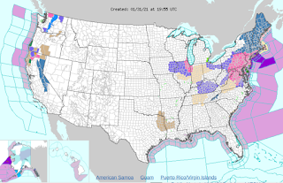
Good Morning! This is the weather forecast for the first of February. The first thing that you need to know for today is that most of the northeast is going to be hit by a snowstorm. As you can see, most of the northeast is in winter weather alerts. The GFS model is showing a moderate snowstorm hitting the northeast and the CMC model is showing the same thing.
The GFS (American Model)
The CMC (Canadian Model)
I wouldn't be surprised if the snow total is up to 30 inches in part of northeast Pennsylvania, northwest New Jersey, and southeast New York. In all, the highest total will most likely be around 30+ inches and will cause low to extreme travel impacts. This storm will most likely be a category 3
The second story of the day is that a snow event has the possibility to form this Thursday. The European Model is showing a significant snowfall while the GFS is showing a small rain/ snow event. If this were to occur, then it would move through the Great Lakes and then move out to Canada. If it were to play out the European model way, then it could cause some significant snowfall for the Great Lakes. If it were to play out like the GFS model, the Great Lakes region would see barely any snowfall.
Euro model
GFS model
The last thing you need to know today is that a low-pressure system will track through the Rockies and will have a total snow total of 30 inches in the extreme elevations. In most of California and Arizona, the rain will be prevalent on Thursday. The rain will be light and steady throughout the region.
The GFS model on Thursday.
Stay Safe!
Two both great websites for weather forecasting!


Wow...good to know!
ReplyDeleteThank you for your feedback everyone!
ReplyDeleteSo cooolllllldddddd! 🥶🥶🥶🥶
ReplyDelete